"See the unseen..."
Kodra's Drone Services LLC
Mapping and 3D modeling
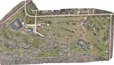
Mapping with a drone is a way to create a current, high-definition map that can be utilized in both print and digital media. Our mapping services go beyond just providing an image; once the map is created, we leverage special software to measure distances, find elevations, and determine the volumes of materials on site.
Our maps are generated from hundreds or even thousands of images captured by the drone in either 4K or 8K resolution, depending on your needs. These images are then uploaded into software that accurately stitches the individual photos together. By utilizing a base station and ground control points, we ensure that our maps achieve surveyor-grade accuracy.
This technology can benefit a wide array of individuals and companies, enhancing profits and sales. For example, we produce real-time maps that help clients visualize available properties and their amenities, such as campgrounds, golf courses, race tracks, and parks. Construction companies can also greatly benefit from our maps, as they provide critical insights for making educated bids on projects. Our maps can be customized to identify vegetation that needs removal, assess the amount of fill needed to reach grade, or calculate the material required for land grading. Additionally, for businesses involved in mining, landscaping, or material supply, we can map and locate stockpiles while providing volume estimates, helping you stay on top of material usage and product output.